Reference points
Datum points are topographic points of known coordinates, which are classified with a different type of entity.
The reference points have their own management table different from that of the topographic points.
These points are used for the functions of calculation of the survey and transformation of coordinates.
Add reference point
You can enter the reference points directly in the CAD window with a dedicated command.
Click on Survey.
Click on Add Reference Point
 .
.The inserted datum points are saved in the active survey subproject.
Reference point table
The program manages the reference points with a specific table.
Click on Survey.
Click Reference Point Table
 .
.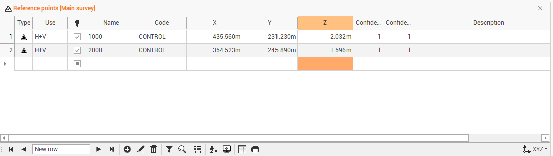
The table is sorted according to the order of insertion of points. From the table you can perform several operations.
The table of topographical points contains the following columns:
Point type: shows the type of point.
Use: to define the use of the control point, if for planimetry only, for elevation only or for planimetry and elevation.
Visible: shows/hides the point.
Name: to change the name of the point.
Code: to change or set a survey code to the point.
E: to change the East coordinate.
N: to change the North coordinate.
Z: to change the elevation.
Confidence: confidence level of the point in planimetry.
Confidence Vertical: confidence level of the point in elevation.
Description: to change or enter the point description.
At the bottom of the table by pressing the icon
 you can change the layout of the table:
LLH: displays coordinates latitude, longitude and ellipsoidal height
ENZ: display the coordinates East, North and elevation.
2nd elevation: toggles the display of the 2nd elevation of the point.
ECEF: display the geocentric coordinate (earth centered, earth fixed).
Save layouts as default: saves the current layout of the tables as the default. It means that the settings applied to the layout (position of columns, display of columns etc...) will be applied as default to open tables later.
Restore default layouts: allows you to undo the changes applied to the table layouts and restore the standard display.
Management of reference points
X-PAD Office Fusion It has a reference point management workspace that allows you to store, organize, and manage datum points in a project-independent store. Reference points can be arranged in groups and for each point and can be assigned coordinates in different systems.
Click on Survey.
Click Reference Point Manager.

This command opens the Reference Point Manager window.
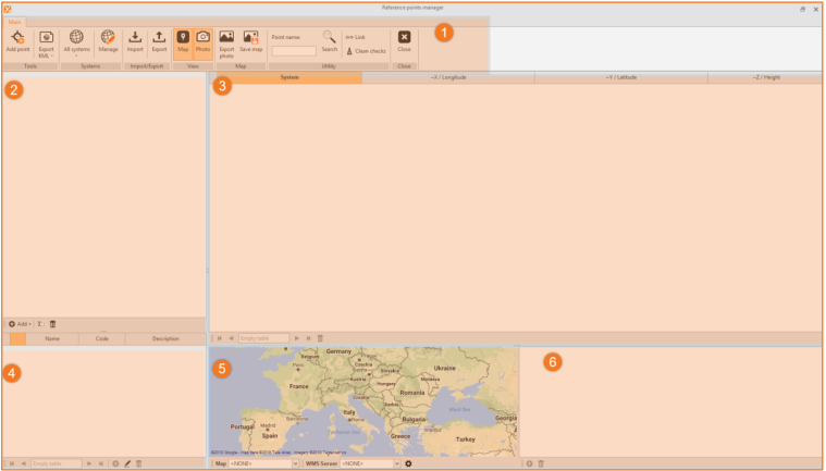
Top bar: menu and main window commands.
Left panel: management panel of the reference points groups.
Central window: window that lists the systems set.
Bottom panel: the summary panel of the reference points in the group.
Map window: It is used to display reference points on a map provided by a WMS provider or service. The panel can also be closed. It also shows the associations between points and photos.
Photo window: it is used to display, add or delete images linked to the reference points.
You must follow the following flow of operations to properly manage the creation phase of datum points:
Set the systems.
Create the groups.
Enter the reference points.
The main menu and commands window has autonomous and specific commands compared to other parts of the program and are divided by groups.
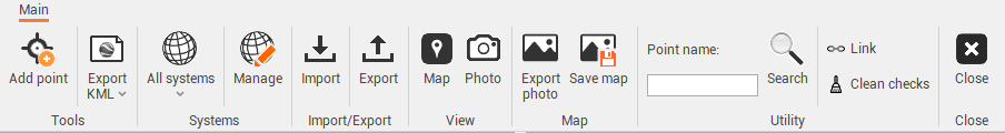
Add point: to add a point to a group with all its properties.
Export KML: to export all data or selected data to a file in the KML format of Google Earth.
All systems: allows to filter the data according to the reference system.
Manage: allows you to add or modify reference systems used for reference points. This allows you to not have to set the reference system for each item, but to use those already set.
Import: to import the reference points from the reference points table of a survey subproject of the open project.
Export: to export selected reference points in the reference points table in a survey subproject open.
Map: toggles the map panel.
Photo: toggles the panel that displays the association between points and photos.
Export photo: to export a JPG file corresponding to the one shown in the map.
Save map: to save a JPG file of the map view as a picture associated with the point.
Search: to look for a reference point according to the name.
Link: to connect the tables to the map.
Clean checks: to clean the selection from all points.
Close: to close the window.
In the panel management panel of the reference points group, you can add the groups and subgroups to which the reference points are categorized.
The bottom of the table contains the following commands for handling: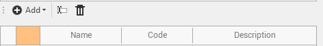
Add: to add a group or subgroup.
Rename: to rename a group or subgroup.
Delete: to delete a group or subgroup.