GeoMax Toolkit
The instrument comes with a pre-installed application called GeoMax Toolkit.
The main purpose of this application is to perform instrument calibrations, set environmental settings and to perform basic measurements.
To start GeoMax Toolkit click GeoMax Toolkit icon from home.

This opens the application.
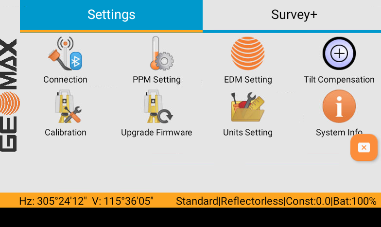
Connection
The Connection app is used to connect or disconnect GeoMax Toolkit software from Hardware components of the instrument.
Do not perform any operation in this page.
PPM Setting
To calculate proper PPM correction values, the atmospheric conditions can be entered or calculated based on elevation.
PPM settings entered here are used in GeoMax Toolkit. To enter PPM settings in X-PAD software use the dedicated functionalities in the X-PAD software.
The settings are.
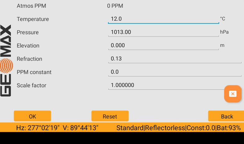
Atmos PPM: the atmospheric ppm is calculated from the values in the fields.
Temperature: sets the temperature.
Pressure: sets the pressure.
Elevation: sets the elevation above mean sea level.
Refraction: refraction coefficient to be used for calculation.
PPM constant: sets the atmospheric PPM.
Scale factor: sets the scale factor.
Click OK to save the settings, click Reset to reset the values to default. Click Back to return to home page without saving the values.
EDM Settings
The settings on this screen defines the active EDM values.
Different settings for measurements are available with Reflectorless (RL) and Prism (IR) EDM modes.
EDM settings entered here are used in GeoMax Toolkit. To change EDM settings in X-PAD software use the dedicated functionalities in the X-PAD software.
The settings are:
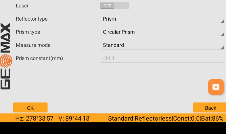
Laser: enables/disables the visible laser beam.
Reflector type: changes the reflector type.
Prism: for distance measurements using prism.
Reflective tape: for distance measurements using Retro reflective targets.
Reflectorless: for distance measurements without prisms.
Prism type: allows to change the prism type. Predefined prisms have a predefined offset. Select User Defined Prism to enter a custom prism.
Measure mode: defines the measurement mode.
Standard: fine measuring mode for high precision measurements.
Fast: quick measuring mode with prisms, with higher measuring speed and reduced accuracy.
Tracking: for continuous distance measurements.
Repeated: for continuous distance measurements with higher frequency of measurements.
Averaging: instrument will take 3 readings which will then be averaged.
Prism constant (mm): this field displays the absolute prism constant for the selected Type. When Type is User Defined Prism or User Defined Reflector this field becomes editable to set a user defined constant.
Tilt compensation
The Tilt Compensation contains tools for levelling up the instrument, determining if tilt corrections will be included in angular measurements and for laser plummet, reticle illumination and screen visibility settings.
The settings are:
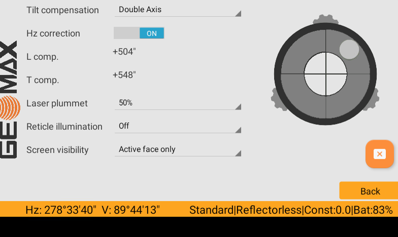
Tilt compensation: defines if the tilt compensation is Off, Single Axis or Double Axis.
Hz correction: enables/disables the tilt corrections values in angular measurements.
Laser plummet: allows to activate and define the intensity of the laser plummet (off to 100%).
Reticle illumination: sets the illumination level of the crosshairs.
Screen visibility: this setting affects units with two displays.
Active face only: only the activate face is visible, the other face is turned off.
Both faces: enables always visibility on both screens.
For more information on how level the instrument refer to Instrument setup.
Calibration
The Calibration menu contains tools to be used for the electronic calibration of the instrument. Using these tools helps to maintain the measuring accuracy of the instrument.
In the Calibration mode screen there are several calibration options.
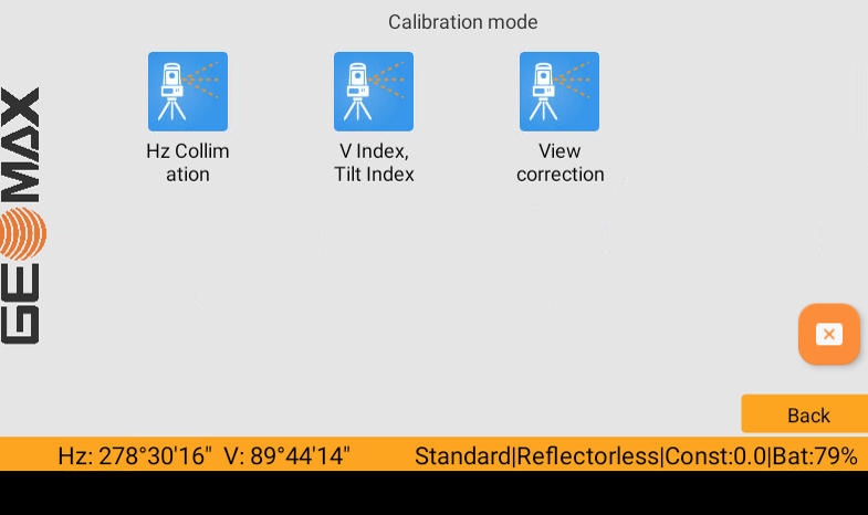
Hz Collimation: the calibration procedure allows to calibrate the line-of-sight error.
V Index, Tilt Index: the calibration procedure allows to calibrate the vertical index error and the compensator index error.
View correction: displays the current calibration values that have been set for Hz-Collimation and V-index and allows to export the calibration data on a file.
For more information on how calibrate the instruments, please refer to the instrument User Manual.
Upgrade firmware
The Upgrade firmware page allows to upgrade the mainboard, the bootloader and the EDM firwmare.
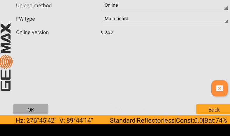
Upload method:
Online: the software verifies online if a new firmware is available (suggested method).
Get from USB system folder: allows to load a firmware from the USB.
FW type: allows to select the firmware type to verify.
If a new firmware is available, click OK to proceed with the update.
Never disconnect power supply during data transfer. Battery capacity must be at least 75% capacity before commencing the upload .
Units setting
Sets the units in GeoMax Toolkit applications.
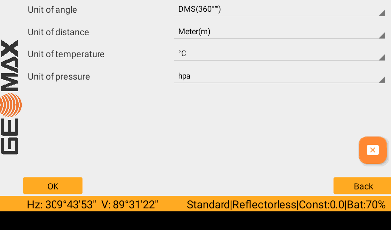
Unit of angle: sets the units shown for all angular fields.
Unit of distance: sets the units shown for all distance fields.
Unit of temperature: sets the units shown for the temperature.
Unit of pressure: sets the units shown for the pressure.
System info
The System Info screen displays instrument, system and firmware information.
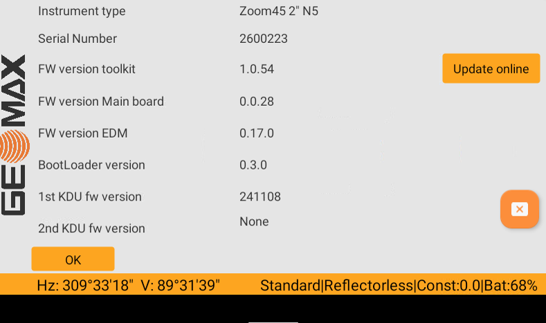
Instrument type: displays the type name of the instrument.
Serial Number: displays the serial number of the instrument.
FW version toolkit: displays the Toolkit firmware version.
FW version Main board: displays the mainboard firmware version.
FW version EDM: displays the EDM firmware version.
BootLoader version: displays the BootLoader version.
KDU fw version: displays the keyboard display module version
Press Update online to update the GeoMax Toolkit application online (requires an internet connection).
Survey
Survey is a basic application for taking measurements and is part of the GeoMax Toolkit.
For demo or simple measurement purposes, no storing of measurements possible.
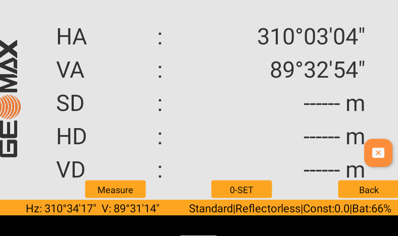
Measure: take a measurement.
0-SET: sets the horizontal angle to 0.
Back: return to previous tab.