Coordinate system
The Coordinate Systems tab is divided into two areas that contain different settings. The first Coordinate system type sets the coordinate system to be used for the coordinate planimetric transformation when calculating the survey. The second Vertical system type allows setting the system for the transformation of the elevations.
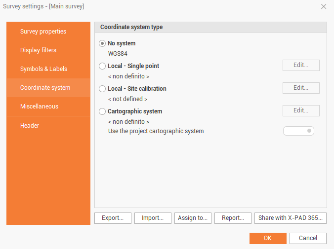
System type - No system
The option does not apply any coordinate system.
System type - Local system point
The option creates a system set up to a local projection referring to a point of origin. Calculates a tangent plane at the indicated point. The option requires the following settings.
Choose Local - Single point.
Click Edit.
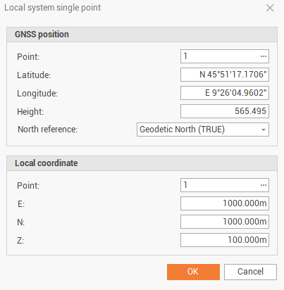
Insert the geographic coordinates of the datum point of the system; If there is already a point with the desired coordinates, you can invoke it typing the name or selecting it from the tables.
Insert the local coordinates of the datum point of the system; If there is already a point with the desired coordinates, you can invoke it typing the name or selecting it from the tables.
Set the values of the coordinates E, N, Z. If the point has been selected from a table, the data is automatically copied in the field, you can also edit them.
System type - Local site calibration
The option calculates a local system set to use point pairs, for which both the geographical coordinates and the corresponding local planar coordinates are known.
Choose Local - Site calibration.
Click Edit.
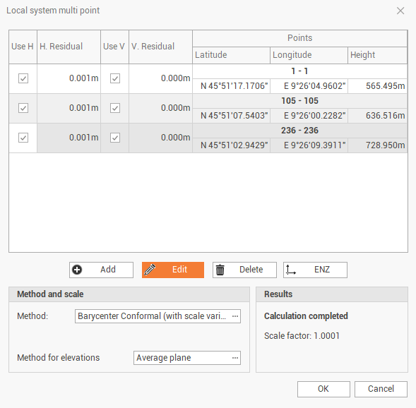
The table shows the pairs of points to be used for calculating the local system. For each pair are also reported the calculated deviation inherent to the coordinates and the elevation. Hit Add to insert the pairs of the point.
Insert the geographic coordinates of the datum point of the system; If there is already a point with the desired coordinates, you can invoke it typing the name or selecting it from the tables.
Insert the local coordinates of the datum point of the system; If there is already a point with the desired coordinates, you can invoke it typing the name or selecting it from the tables.
Click OK.
Repeat steps 3, 4 and 5 for the other pairs of points.
Options and commands:
Use H: enables/disables the use of the point pair's planimetric coordinates.
Use V: enables/disables the use of the point pair's altimetric coordinates.
Add: allows you to add a pair of points to the calibration system.
Edit: allows you to change the selected coordinate pair.
Delete: allows you to erase the selected coordinate pair.
ENZ: allows to change the display of the coordinates of the pairs of points from E, N, Z to longitude, latitude, height.
At the bottom of the window is visualized the calculation method chosen by the program based on the number of localization points inserted; in the Scale field you can set the kind of scale to apply.
Method:
Rigid body (unscaled): no scale factor is applied; the original distances between the measured points are maintained.
Conformal (scaled): a scaling factor is calculated and applied to allow an adjustment of the points measured at the reference points.
Helmert 3D (7 parameters): geometric transformation with 7-parameters within a three-dimensional space. A scale factor is calculated and applied.
Method for elevations (applies for rigid body and conformal transformations):
Average plane: elevation is calculated referring to an average plane between the control points.
Average shifts: elevation is calculated referring to the average shift between the control points and an horizontal reference plane.
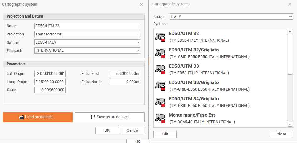
System type - Cartographic system
The option allows you to set the coordinate system, if the option Use the project cartographic system is not selected, you can set a different system than the project system (see Project settings )
If the calculation of the survey has already been performed, and a different transformation option is selected, the program makes the following requests:
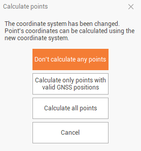
Don’t calculate any points: Sets the coordinate system without re-calculating the coordinates.
Calculate only points with valid GNSS positions: sets the coordinate system and recalculates only the points that have a valid GPS positions.
Calculate all points: sets the coordinate system and recalculate all points.
Cancel: cancels the procedure to set up the coordinate system.
Vertical system type
For each type of system type it is possible to associate a corresponding vertical transformation system; the options are as follows:
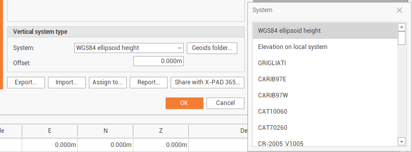
WGS84 ellipsoid height: the option uses the ellipsoidal height of the points as the elevation.
Elevation on local system: the option calculates the elevation based on the data of the local system (only if it set a local system). The option is activated by selecting Local – Single point and Local - Site calibration.
Reference ellipsoid height: sets the height referred to the reference ellipsoid of the cartographic system (only if a cartographic system is set). The option is activated by selecting Cartographic system.
Local geoid files: sets the height calculated using one of the selected geoids, previously downloaded from Localization package (see Localization package ).
Offset: adds the value set to the calculated elevation.
Manage coordinate systems
At the bottom of the page there are some commands to manage the coordinate systems:
Export: to export the current coordinate system in the X-PAD coordinate system file format (pcs).
Import: to import a coordinate system in the X-PAD coordinate system file format (pcs).
Assign to: to select the survey subproject to which assign the current coordinate system.
Report: the options allows to create a report of the current coordinate system.
Share with X-PAD365: to share the current coordinate system within the X-PAD365 chat system.