Coordinates
Use the command Coordinates to create a point to the current survey subproject entering the point coordinates.
Click Draw.
Click click below Point to open drop down menu.
Click Coordinates.
This function opens a table on the right side of the window.
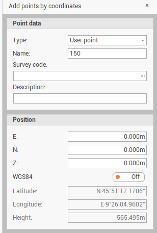
Enter the requested information to create the topographic point.
Type: selects if point is a User point or a Reference point.
Name: the name ID of the point.
Survey code: selects the survey code to assign to the point from the list of Survey code assigned to the project.
Description: the point description.
Position: the position in E,N,Z.
WGS84: turns on WGS84 option to activate the WGS84 coordinate for the point. It is possible to edit the WGS84 coordinates and E,N,Z are recalculated. A cartographic system assigned to the project is required.
Or click on the graphic view to create the point graphically.