GIS manager
 + GIS |
  + GIS |
  + GIS
+ GIS
A GIS feature consists of a group of properties which describe elements of the measured area.
The GIS features are used to measure and describe elements of the measured area with the scope to create a GIS system.
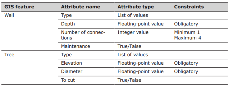
Example of GIS features:
The library of GIS features with the corresponding attributes is user-definable.
Every GIS feature can be associated to a survey code.
Saving a point: the software checks the survey code associated with the point. If a GIS feature is associated to the survey code, a window is displayed allowing to add the corresponding attributes.
Saving a line: the attributes can be assigned to the first point of the line, to all points or to the last point of the line. In most cases, the last point of the line is the best solution because more information about the line is available.
All information associated to points can be exported in different ways. For example as ESRI Shape file, as labels in the DXF export or in an ASCII file.
Create a GIS feature: how to create GIS feature in the GIS features manager.
Edit a GIS feature: how to edit a GIS feature.
Delete a GIS feature: how to delete a GIS feature.
Save and load GIS features: how to save and load a GIS features list.
Select a GIS features library as default for a site: how to select a GIS features library as default for a site and for a collaborative site.
Assign a GIS feature to a code: how to assign a GIS feature to a code, to record the attributes during the survey.