
This utility calculates the elevation of topographic points from a reference surface.
-
Click Surface.
-
Click Tools to open the menu.

-
Click Point elevation from surface.
-
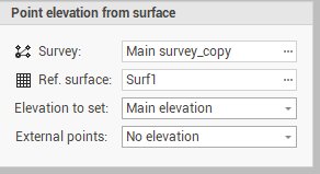
The command opens a new panel on the right.
-
Survey: indicates the survey subproject of the points to be projected.
-
Ref. surface: indicates the surface subproject from which to extract the points.
-
External points: allows to choose the action that the program performs for points outside the reference surface. The options are as follows:
-
No elevation: the point elevation is not changed.
-
Fixed elevation: associates external points to a fixed elevation.
-
Keep existing: maintains the existing elevation.
-
-
-
Click Calculate to adjust the points.