
This utility generates new topographic points from a reference surface, according to different modes.
-
Click Surface.
-
Click Tools to open the menu.

-
Click Points from surface.
-
The command opens a new panel on the right.
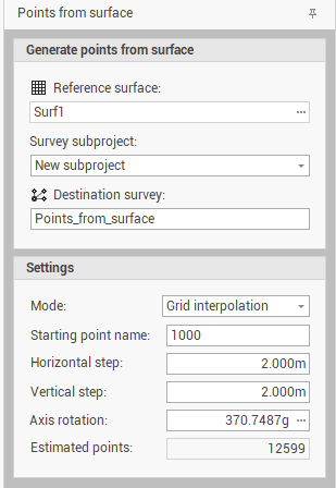
-
Reference surface: indicates the surface subproject from which to extract the points.
-
Survey subproject: indicates the survey subproject where to save the points created. The options are:
-
New subproject: creates a new survey subproject where to save the points created by the processing.
-
Existing subproject: allows to select an existing subproject where to save the points created by the processing.
-
-
Destination survey: sets the name of the subproject to be created or to choose the name of the existing one to use according to the option chosen in the Survey subproject box.
-
Mode: allows to choose which entities to extract the points from. The options available are:
-
Triangle vertices: points are extracted only from the vertices of the triangles.
-
Breaklines & Boundary lines: points are extracted only from the breaklines and boundary lines.
-
Grid interpolations: points are extracted according to a regular grid. If this method is selected, you can enter the horizontal and vertical step and the axis rotation of the grid.
-
-
Starting point name: sets the name of the first point. The next points will have a progressive numbering.
-
Estimated points: indicates the estimation of the number of points generated by the calculation.
-
-
Click Generate to generate the points.