
-
Use the command Azimuth & Distance to create a point to the current survey subproject entering azimuth/bearing and distance from a reference point.
-
Click Draw.
-
Click click below Point to open drop down menu.
-
Click Azimuth & Distances.
-
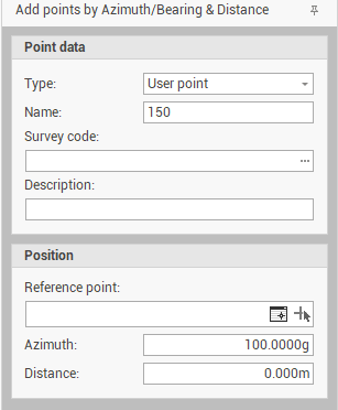
This function opens a table on the right side of the window.
-
Enter the requested information to create the topographic point.
-
Type: selects if point is a User point or a Reference point.
-
Name: the name ID of the point.
-
Survey code: selects the survey code to assign to the point from the list of Survey code assigned to the project.
-
Description: the point description.
-
Reference point: selects from point list or on the graphic view the reference point.
-
Azimuth/Bearing: the azimuth/bearing from the reference point.
-
Distance: the distance from the reference point.
-
-
Or click on the graphic view to create the point graphically.